- Home
- Events
- Investigations
- News
- OPINION
- Police/Fire/EMS
- Politics
- Sports & Schools
Blizzard Warning In Effect For The Tri-State Area

A Blizzard Warning is now in effect for the Huntington area beginning at 1pm today. The worst of the storm will impact the area tonight and Tuesday. Below is the official National Weather Service forecast for the area.
- Today Snow, mainly after 9am. High near 29. Wind chill values between 10 and 15. Blustery, with a northeast wind 17 to 24 mph. Chance of precipitation is 80%. Total daytime snow accumulation of 1 to 3 inches possible.
- Tonight Snow with widespread blowing snow. The snow could be heavy at times. Some thunder is also possible. Low around 22. Wind chill values between 5 and 10. Windy, with a north wind 26 to 29 mph, with gusts as high as 39 mph. Chance of precipitation is 100%. New snow accumulation of 8 to 12 inches possible.
- Tuesday Snow with widespread blowing snow. The snow could be heavy at times. Some thunder is also possible. High near 26. Wind chill values between 5 and 10. Windy, with a north wind 22 to 28 mph, with gusts as high as 39 mph. Chance of precipitation is 100%. New snow accumulation of 7 to 11 inches possible.
- Tuesday Night Light snow, mainly before midnight. Low around 18. Wind chill values between 5 and 10. North wind 14 to 16 mph. Chance of precipitation is 90%. New snow accumulation of 1 to 2 inches possible.
- Wednesday Mostly sunny, with a high near 27. North wind 10 to 15 mph.
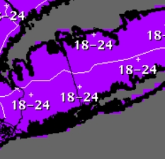
Total Forecast Graphic (Inches):
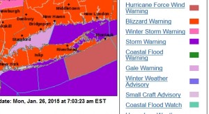
Blizzard Warning In Red Shaded Areas:
Facebook Comments must be signed into Facebook


.png)
You must be logged in to post a comment Login